Santa Barbara
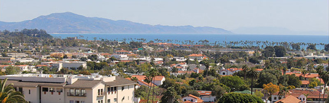
Santa Barbara is the county seat of Santa Barbara County, California, United States. Santa Barbara situated on an east-west trending section of coastline, the longest such section on the West Coast of the United States, the city lies between the steeply-rising Santa Ynez Mountains and the Pacific Ocean. Santa Barbara’s climate is often described as Mediterranean, and the city is widely known as the “American Riviera.” As of the census of 2010, the city had a population of 89,045, Asian population in Santa Barbara Metro is around 5%, 70% and more are Caucasians. The population of the entire county in 2010 was 423,895.
In addition to being a popular tourist and resort destination, the city economy includes a large service sector, education, technology, health care, finance, agriculture, manufacturing, and local government. In 2004, the service sector accounted for fully 35% of local employment. Education in particular is well-represented, with five institutions of higher learning on the south coast (the University of California, Santa Barbara, Santa Barbara City College, Westmont College, Antioch University, and the Brooks Institute of Photography.) The Santa Barbara Airport serves the city, as does Amtrak. U.S. Highway 101 connects the Santa Barbara area with Los Angeles to the south and San Francisco to the north. Behind the city, in and beyond the Santa Ynez Mountains, is the Los Padres National Forest, which contains several remote wilderness areas.
KSBT-LD Ch32 Coverage Map
聖巴巴拉
Santa Barbara聖巴巴拉是美國加利福尼亞州聖巴巴拉郡的郡城。聖巴巴拉位於加州東西向的部分海岸線,也是美國西海岸最長的城市部分,這個城市是在急劇上升的聖塔陽茲山和太平洋之間。 Santa Barbara的氣候常常被形容為地中海,被廣泛地稱為“美國海濱城市。”截至2010年的人口普查,城市人口為89,045,亞裔人口在聖巴巴拉有5%左右,70%以上是白人。據2010年的統計,聖巴巴拉全郡人口為423,895。
Santa Barbara聖巴巴拉是一個著名的旅遊和度假勝地,城市經濟主要是服務行業,還有教育,科技,醫療保健,金融,農業,製造業,和當地政府。2004年,服務業佔35%的本地就業率。尤其是教育,設有五所出名的高等院校(美國加州大學聖巴巴拉分校,聖巴巴拉城市學院,韋斯特蒙特學院,安蒂奧克大學,和布魯克斯攝影學院)。聖巴巴拉建有機場和Amtrak火車站。美國101號免費高速公路連接著聖巴巴拉地區的北部到南部以及舊金山與洛杉磯。在城市的後面Santa Ynez高山,是Los Padres國家森林。